<a href="http://www.flickr.com/photos/hectormilla/195951318/sizes/o/in/photostream/">Hector Milla</a>/Flickr
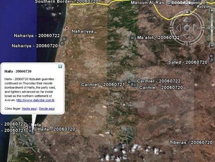
Since Google launched its Google Earth feature in 2005, the company has become a worldwide leader in providing high-resolution satellite imagery. In 2010, Google Earth allowed the world to see the extent of the destruction in post-earthquake Haiti. This year, Google released similar images after Japan’s deadly tsunami and earthquake. With just one click, Google can bring the world—and a better understanding of far-away events—to your computer.
There is one entire country, however, that Google Earth won’t show you: Israel.
That’s because, in 1997, Congress passed the National Defense Authorization Act, one section of which is titled, “Prohibition on collection and release of detailed satellite imagery relating to Israel.” The amendment, known as the Kyl-Bingaman Amendment, calls for a federal agency, the NOAA’s Commercial Remote Sensing Regulatory Affairs, to regulate the dissemination of zoomed-in images of Israel.
When asked about the regulation, a Google spokeswoman said to Mother Jones, “The images in Google Earth are sourced from a wide range of both commercial and public sources. We source our satellite imagery from US-based companies who are subject to US law, including the Kyl-Bingaman Amendment to the National Defense Authorization Act of 1997, which limits the resolution of imagery of Israel that may be commercially distributed.”
And it’s not just Israel. The regulation also applies to the occupied territories. It’s why Human Rights Watch can’t provide detailed imagery of the Gaza Strip in its reports. Of course, this regulation cuts both ways; one also cannot see the destruction in Sderot resulting from rockets sent out of Gaza.
But, the impact of the regulation might be dwindling; after all, the US can only regulate the actions of American corporations. Turkey recently announced that its GokTurk satellite will provide high-resolution imagery of Israel when it becomes operational in 2013. Israel is unhappy with this possibility: An Israeli official told Al-Arabiya, “We try to ensure that we are not photographed at high resolutions, and most (countries) accommodate us.” The official adds: “Should we request this of the Turks? We won’t ask for it. There is no one to talk to.”