<a href=" http://en.wikipedia.org/wiki/Climate_change">Liam Gumley</a>/Wikimedia
Ever come across someone who wants visual proof that climate change is real? Well, now it’s at your fingertips. Thanks to a joint effort by California universities and research centers, the California Energy Commission, and Google, Golden State residents now have access to a brand new interactive tool that showcases the effects of climate change. The website, Cal-Adapt.org, culls a wealth of information from the the state’s scientific community and reformats it into easy-to-use charts and maps.
You can tailor the data to your specific location and voilá: The website will generate personalized local climate snapshots, wildlife risk areas, and sea level changes. Adjust the scale at the top of the tools section and you’ll see changes between decades. The site’s aim is to make the information publicly available, so your results can be easily downloaded.
I gave the eight climate tools a whirl by using my own address:
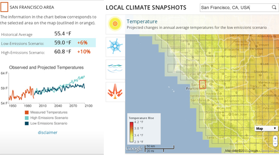
1) Here’s the climate snapshot for the San Francisco area. The high and low emissions scenarios correspond with the map to the right, showing temperature rises based on location.
2) The beauty of these graphs is that you can get a full decadal spectrum. This one shows monthly temperature increases from 1960 to 2090, a 150 year spread.

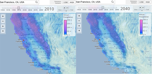
3) Here are two maps that compare current precipitation to the high emissions precipitation prediction for 2040. The side by side comparison portrays an overall drop in annual precipitation.
And this website is full of extra goodies: There’s a massive publication archive dating back to the 1980s that includes climate articles on electricity demand, shrinking beaches, and intensifying heat waves. The “What is California Doing About Climate Change” section is embarrasingly scant, but as a consolation prize, Cal-Adapt is launching the Historic Photo Hunt Challenge. In a Geocaching fashion, Cal-Adapt will send out the GPS coordinates of photos taken in the 1920s and 1930s. Photographers will then go to those locations, take snapshots, and send them back to scientists, all in an effort to understand how various landscapes have changed over time. Finally, on a fun note, you can customize your background with one of several California scenes by clicking the arrows above the “About Cal-Adapt” box.