![]() Sea Surface Temperature (SST) Anomaly color scale.
Sea Surface Temperature (SST) Anomaly color scale.
![]() Vegetation Anomaly percent color scale.
Vegetation Anomaly percent color scale.
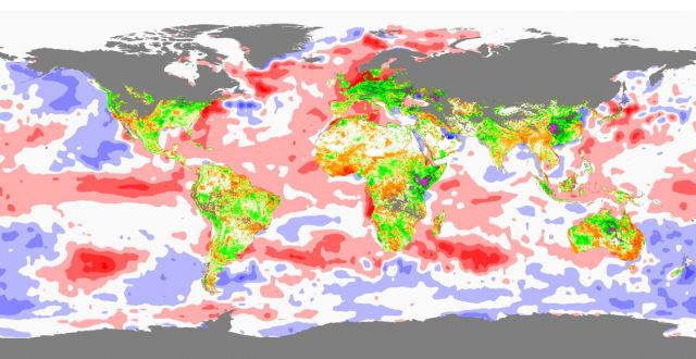
This map from the NASA/Goddard Space Flight Center Scientific Visualization Studio shows a snapshot of the relationship between environmental extremes and a deadly disease outbreak in Africa in January 2007. (Click here for larger image.) Specifically:
- Unusually high sea surface in the equatorial waters of the Indian and Pacific Oceans (red)
- Which fueled persistent, heavy rains over East Africa
- Which caused an anomalous burst of plant growth in East Africa (magenta)
- Which created a perfect storm of conditions for the emergence of mosquitoes that spread Rift Valley fever
Rift Valley Fever is passed by mosquitoes from viral reservoirs in bats to livestock and people. The 2006-2007 Rift Valley Fever outbreak spread through Kenya and Somalia, killing 148 people and infecting many more, causing costly closures of livestock markets and costing the Kenyan government $2.5 million for vaccine deployment.
 Click for larger image: NOAA/NCDC
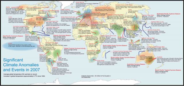
The cascade of factors that ended in the death of many emerged from the record-breaking climate extremes of 2007. The map above from NOAA’s National Climatic Data Center shows a few of them. Click it for a larger image.


